
Transportation has been a recurring issue at UNI throughout its history. However, in the early years, students had transportation concerns that were different from finding a parking place on campus.
Back in 1876 when UNI opened as the Iowa State Normal School (ISNS), the city of Cedar Falls had a population of 3,500 (compared to today's 30,000) and was located several miles from campus. Students living in Cedar Falls had to either walk on dirt or mud "sidewalks" or pay for a hack (horse and buggy) in order to get to campus. This was time consuming and tiring.
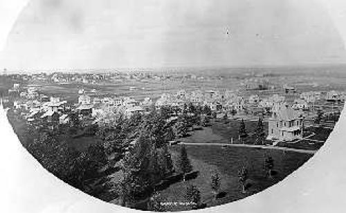
By 1896, the date of above photograph, Cedar Falls and the ISNS community were growing closer to each other. The photo was taken looking northeast from the middle of campus. The current Honors Cottage is the large brick building on the right lower side. Normal Street, now called College Street, runs in front of this building.
Transportation via horse and buggy was still popular, however. This is a photograph from the 1905 yearbook of the Normal Hill postman Charlie Bley and his old horse Dick.
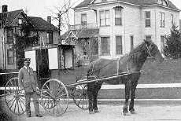
The two had been delivering mail to area residents for thirteen years when this photo was taken.
Roads and Sidewalks
For many years the roads surrounding the ISNS were dirt. When it rained and when the snow melted in the spring, getting around was very messy. Early sidewalks on campus were simply wooden planks to protect one's feet. The streets and sidewalks were not paved until the early 1900s.
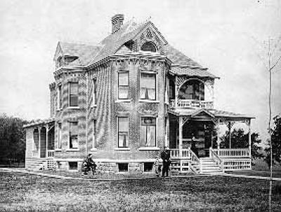
The above photograph shows President Homer Seerley and his family outside the original President's home, now called the Honors Cottage, in 1891. The sidewalks are constructed of wooden planks.


Electric Trolley
As early as 1892 the Normal School had hopes for better transportation for its students. Electric motors seemed to be the answer.
An electric street car or motor line was proposed that year to connect Cedar Falls and Waterloo with tracks extending south to the Normal School. Although the students were excited about the idea, it wasn't until late 1897 that a street car began operating in the area.

The first trolley route traveled south down Main Street, turned right on 24th Street (or Seerley Boulevard), and then right again on Normal Street. The two passenger cars were powered by electricity from a storage battery and charged by a small gas engine.

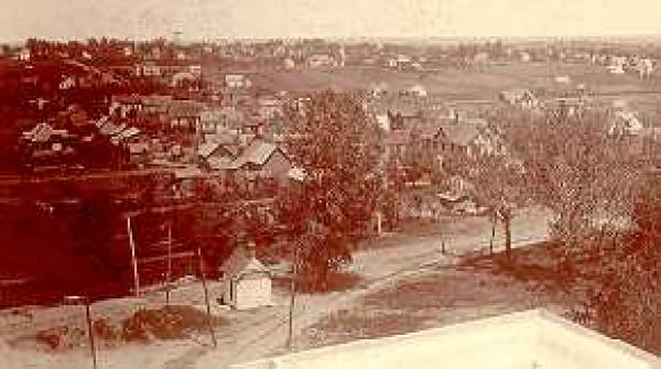
In October 1900, a railroad line was laid on the Normal School grounds running east around and behind the Auditorium Building. This was used to deliver construction materials and fuel. In the photo below you can see the trolley tracks in the lower section. It was taken from the top of the Auditorium Building (Lang Hall) looking northeast.
By 1901, a street car depot or waiting station was erected on the west side of campus behind the Auditorium Building. The line extended from Normal Street in the north and picked up students on the west side.
1901 campus map with street car line
In 1907 the streetcar line was moved so that it entered the Normal School from the south. The depot was moved to the northeast corner of campus near the Auditorium Building.


A 1919 map, printed in the College Eye student newspaper, shows the trolley tracks entering campus from the south and extending to the heating plant. On May 18, 1941, trolley service in the area ended and was replaced by a bus system.
Automobiles and Parking
Parking has been an issue on campus for about as long as there have been vehicles needing parking spaces! By 1924, when the Iowa State Teachers College (UNI) had a fall enrollment of around 2700, up to seventy-five cars were parking behind Old Gilchrist Hall on any given day. The student newspaper estimated that three-fourths of those vehicles were driven by students. Many students would drive their family's car to campus from the surrounding areas. One year later, a new parking lot was added south of Sabin Hall. About seventy-nine cars could park there.
In addition to parking in lots, people were free to park on the street.
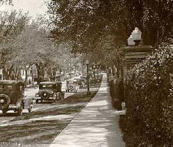
The cars in the above photo are parked along 23rd Street. The brick columns to the right border the sidewalk leading up to the very east end of Bartlett Hall, now the Student Services Center. There are houses on the left in the photo where the University Book and Supply is currently located. Notice anything missing? Parking meters!
Students could also park in the circular drive in front of the Auditorium Building.

In the fall 1940, a parking lot was constructed west of Latham Stadium (near the current site of the UNI-Dome) with space for five hundred cars.
In April 1947, after a college committee created new parking regulations, a campus policeman was hired to enforce the rules. However, many people challenged the new practice of paying their parking fines to the college business office. This was soon turned over to the local authorities. Currently, campus offenders pay their fines at the Public Safety Office.
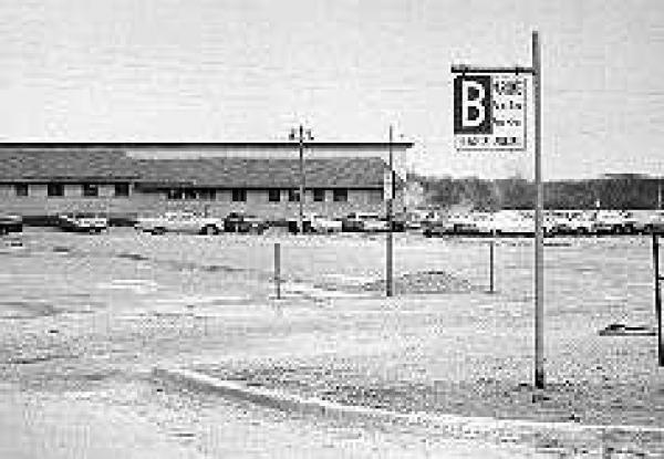
Above is a photograph of the A parking lot west of the current Gilchrist Hall. If you look closely, you can see the top of Gilchrist Hall over the wooden building in front of it. Notice the lot is covered in gravel.
At one time, parking was allowed in the center of campus near the library.
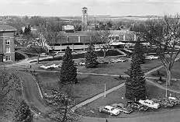
As you can see in the above 1964 photo, cars could park directly in front of the library and drive completely around the circle. This site would later become home to the Maucker Union.
These maps show the parking areas, highlighted in yellow, that were available to faculty, staff, and students in 1953, 1965, 1975, 1985, and 1997. Click on each to view an enlarged image.
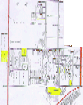
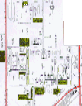
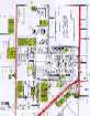
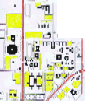
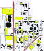
1953 | 1965 | 1975 | 1985 | 1997
In the above thumbnail images, north is at the top. Three streets have been highlighted in orange on each map to help orient the viewers: University Avenue is the street cutting diagonally across the bottom right corner; College Street runs north and south on the far right side; and Hudson Road runs north and south on the left side. By comparing just the thumbnail images you can see how the number of parking lots has increased since 1953.
Other Modes of Transportation
Bicycles were also a common mode for transportation. Presently, the number of bicycles in use on campus is on the rise. In the early years, bicycles may have been only used for recreation and not getting from here to there.

One solution to the parking crunch on campus was the Panther Shuttle bus system. The Met Transit Authority provided free bus service, travelling around campus, and delivering students to the College Square area, ROTH, and Thunder Ridge area. The service began January 12, 1998 and ended for the semester March 13. This, however, was not the first time students had a campus bus service. A similar service began in the spring of 1948.
Actual display and web version created by Library Assistant Susan A. Basye, October 1998; December 1998; slightly edited by University Archivist Gerald L. Peterson, October 2014; last updated, October 31, 2014; (GP).